|
PANAMA
CANAL
+
BOAT
& LAND
TOURS
(view our SLIDE SHOW below)
 The Panama
Canal was built as a short cut between the Atlantic and Pacific
Oceans, saving time, money and wear and tear on vessel and crew,
instead of sailing around treacherous Cape Horn at the southernmost tip of South
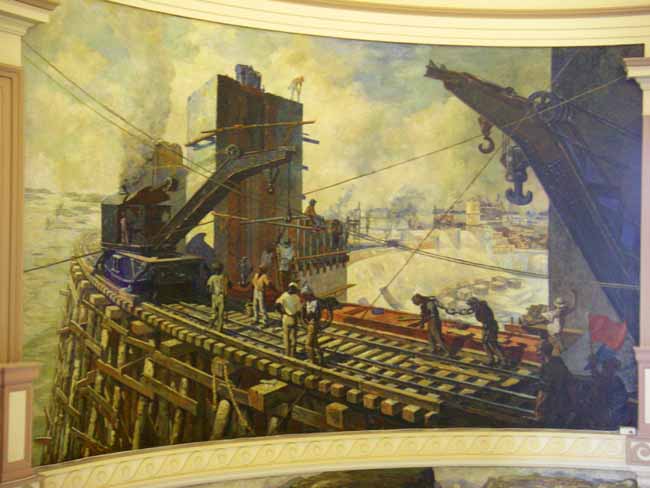
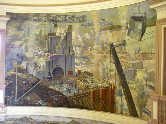
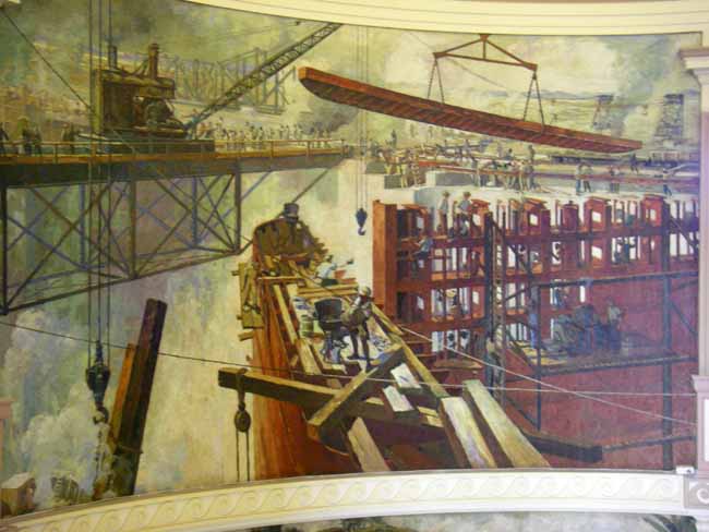
America - a savings of 8,000 miles. The French undertook the
historic project of carving a channel through the dense jungles and
mountains in the
1880's and 1890's. But 22,000 worker deaths due to disease
(yellow fever and malaria) and
accidents and eventual financial bankruptcy ended their attempt.
The project was resurrected by the Americans in 1904 and the Canal
completed in 1914. The Americans turned control of the Canal
over to Panama in 2000.
The Panama Canal "shall remain open to the peaceful and
uninterrupted transit of vessels of all nations" - if Panama ever
restricts passage, the U.S. resumes control of the Canal. The Panama
Canal was built as a short cut between the Atlantic and Pacific
Oceans, saving time, money and wear and tear on vessel and crew,
instead of sailing around treacherous Cape Horn at the southernmost tip of South
America - a savings of 8,000 miles. The French undertook the
historic project of carving a channel through the dense jungles and
mountains in the
1880's and 1890's. But 22,000 worker deaths due to disease
(yellow fever and malaria) and
accidents and eventual financial bankruptcy ended their attempt.
The project was resurrected by the Americans in 1904 and the Canal
completed in 1914. The Americans turned control of the Canal
over to Panama in 2000.
The Panama Canal "shall remain open to the peaceful and
uninterrupted transit of vessels of all nations" - if Panama ever
restricts passage, the U.S. resumes control of the Canal.
The Panama
Canal is one of the world's greatest engineering marvels.
Initially, the Canal was envisioned not to require locks, but just
to be a simple passageway between the two Oceans. While the
Atlantic Ocean side sees less than a 2 foot tidal change, the
Pacific side has a 20 foot tidal range. Because of this, the
 Canal would experience great currents rushing through it as the
Pacific tides rise and fall relative to the Atlantic. It was
decided that this tidal current would be too much for vessels to safely navigate.
Thus the idea of "locking" through the Canal was conceived. To
create a reservoir of water from which to supply the lock chambers,
the Chagres River was dammed up, creating the largest man-made lake
at the time, Gatún Lake. Because of the abundant rain forests
in the area and the copious rainfall during rainy season (that we've
been witnessing this past week as I write), Gatún Lake is pretty much
assured of always having enough water to operate the locks.
While much of the Canal Zone is dedicated to national parks and wildlife
reserves, care still must be made to protect the rainforests and
thus the watershed. Canal would experience great currents rushing through it as the
Pacific tides rise and fall relative to the Atlantic. It was
decided that this tidal current would be too much for vessels to safely navigate.
Thus the idea of "locking" through the Canal was conceived. To
create a reservoir of water from which to supply the lock chambers,
the Chagres River was dammed up, creating the largest man-made lake
at the time, Gatún Lake. Because of the abundant rain forests
in the area and the copious rainfall during rainy season (that we've
been witnessing this past week as I write), Gatún Lake is pretty much
assured of always having enough water to operate the locks.
While much of the Canal Zone is dedicated to national parks and wildlife
reserves, care still must be made to protect the rainforests and
thus the watershed.
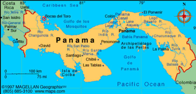
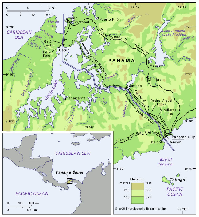
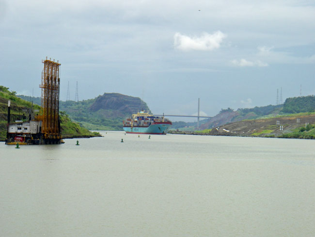
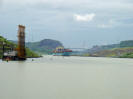
 The
Panama Canal runs north-south across the narrow, 50-mile wide isthmus of
Panama, with the city of Colon located on the north, Atlantic/Caribbean side and
Panama City on the south, Pacific side. The Canal is roughly half the width
of the Houston ship channel in places. It takes 8 - 10 hours to
transit the Canal non-stop, although a typical transit is
about 24 hours. There are 2,
bi-directional, lanes of traffic through each lock system, so 2 ships can be
going through adjacent locks at the same time (same or opposite direction), although independent of each other. A vessel entering from one ocean is
raised a total of 80
feet through 3 sets of locks, it then sails through the Canal and Gatún
Lake, and
is then
lowered 80 feet through 3 more sets of locks to the other ocean. The
Panama Canal runs north-south across the narrow, 50-mile wide isthmus of
Panama, with the city of Colon located on the north, Atlantic/Caribbean side and
Panama City on the south, Pacific side. The Canal is roughly half the width
of the Houston ship channel in places. It takes 8 - 10 hours to
transit the Canal non-stop, although a typical transit is
about 24 hours. There are 2,
bi-directional, lanes of traffic through each lock system, so 2 ships can be
going through adjacent locks at the same time (same or opposite direction), although independent of each other. A vessel entering from one ocean is
raised a total of 80
feet through 3 sets of locks, it then sails through the Canal and Gatún
Lake, and
is then
lowered 80 feet through 3 more sets of locks to the other ocean.
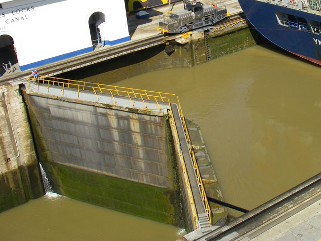
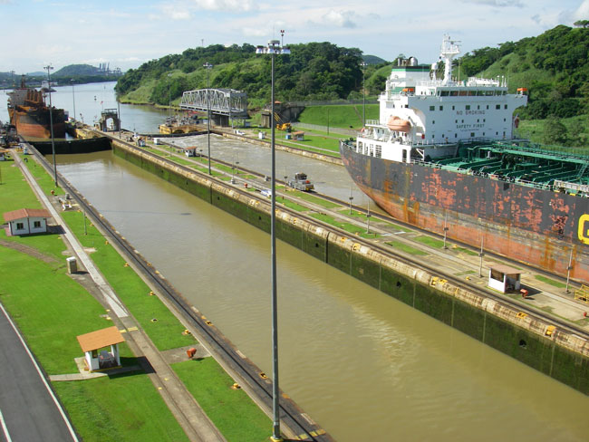
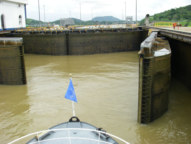
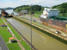
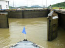
In more detail, a vessel entering the
Panama Canal from the Atlantic (Caribbean) side first "locks up" through the Gatún Locks, a series of 3 locks. (Locks are named for the town that's
closest to them.) Then the vessel enters Gatún Lake, 80 feet above the
Atlantic. Then it passes through the narrowest part of the Canal,
Gaillard Cut, which crosses the Continental Divide which marks the highest
point of land that had to be excavated.
 The "lock down" process begins
first with 1 set of locks at the Pedro Miguel Locks. A short distance
later are the 2 sets of locks at the Miraflores Locks,
which then open up to
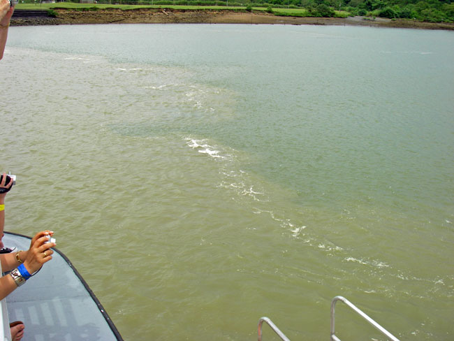
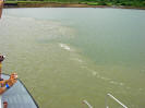
the Pacific. Leaving the last Miraflores Lock, the fresh water of Lake
Gatún is released into the salty water of the Pacific Ocean, creating a
noticeable "trash line" of sorts. Here the birds hang out
looking for a tasty feast, as fresh water fish die in the salt water and the
salt water fish are temporarily stunned by the fresh
water. The "lock down" process begins
first with 1 set of locks at the Pedro Miguel Locks. A short distance
later are the 2 sets of locks at the Miraflores Locks,
which then open up to
the Pacific. Leaving the last Miraflores Lock, the fresh water of Lake
Gatún is released into the salty water of the Pacific Ocean, creating a
noticeable "trash line" of sorts. Here the birds hang out
looking for a tasty feast, as fresh water fish die in the salt water and the
salt water fish are temporarily stunned by the fresh
water.
Water is supplied from Gatún Lake to the
lock chambers
through a system of culverts 18 ft. in diameter that extend under the lock
chambers and from the side and center walls.
The whole
raising and lowering process via the locks is done strictly by gravity - no
pumps are
 used. A lock chamber is filled, or emptied, of 26
million gallons of fresh lake water in 8 minutes; afterwards it takes 2
minutes for the lock gates to open. The steel lock gates are 7 feet
thick, and weigh up to 662 tons; the lower part is hollow and sealed with air so
they sort of "float"; they are so well balanced that it takes
only a 25
horsepower electric motor to open and close a gate.
(Actually, there are 2 motors that are used, one as backup to the other.) The
lock gates, originally mechanical, are now hydraulic requiring less energy
to operate and less maintenance. A single gate hinge weighs 16 tons. used. A lock chamber is filled, or emptied, of 26
million gallons of fresh lake water in 8 minutes; afterwards it takes 2
minutes for the lock gates to open. The steel lock gates are 7 feet
thick, and weigh up to 662 tons; the lower part is hollow and sealed with air so
they sort of "float"; they are so well balanced that it takes
only a 25
horsepower electric motor to open and close a gate.
(Actually, there are 2 motors that are used, one as backup to the other.) The
lock gates, originally mechanical, are now hydraulic requiring less energy
to operate and less maintenance. A single gate hinge weighs 16 tons.
|
THE MAX & PANAMAX
A lock's
dimensions are (LxWxD):
1000' x
110' x 83'
Panamax
vessel dimensions (built specifically for
Canal) are:
965' x
106' x 39.5'
That
leaves only a 2' clearance on either side
and 35' fore and aft
-
- -
The
current expansion project will result in a
new set of locks:
1400' x
180' x 60' |
|
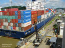 The
largest vessels that can go through the existing Canal are called "Panamax",
and can carry 4,500* containers. A third of the world's ship traffic today are "post-Panamax"
- too big to go through the Canal - and can carry 12,500* containers.
(A 3rd traffic lane, also with 3 sets of locks, is now being built that will
accommodate the larger "post-Panamax" ships. See more below on the
expansion project.) With the current lock chambers, the Panamax ships literally have only a
24-inch clearance on each side of the ship, and only a few feet forward/aft of the lock gates.
(See box at right.) Ships
are guided through the lock chambers by "mules", locomotives on a track
-
ships
use their own propulsion to make their way through, although the mules have
powerfully strong brakes to restrain
unwanted movement. Larger
ships may have 4 to 8 mules guiding it. The prototype Mitsubishi mules cost
around $2.5 million each. The
largest vessels that can go through the existing Canal are called "Panamax",
and can carry 4,500* containers. A third of the world's ship traffic today are "post-Panamax"
- too big to go through the Canal - and can carry 12,500* containers.
(A 3rd traffic lane, also with 3 sets of locks, is now being built that will
accommodate the larger "post-Panamax" ships. See more below on the
expansion project.) With the current lock chambers, the Panamax ships literally have only a
24-inch clearance on each side of the ship, and only a few feet forward/aft of the lock gates.
(See box at right.) Ships
are guided through the lock chambers by "mules", locomotives on a track
-
ships
use their own propulsion to make their way through, although the mules have
powerfully strong brakes to restrain
unwanted movement. Larger
ships may have 4 to 8 mules guiding it. The prototype Mitsubishi mules cost
around $2.5 million each.
* This is based on standard 20-foot equivalent units (TEU)
 At the narrowest part of the Canal which cuts
through the Continental Divide, Gaillard (aka Culebra) Cut, Panamax vessels
cannot safely pass each other now. Because of this, only north-bound Panamax vessels are
underway from 5:00 a.m. - 12:00 a.m.; south-bound Panamax move in the afternoon; after 6:00 p.m.
Panamax vessels that had not
completed the transit and got caught in between and tied up somewhere on the
Canal are now able to proceed. As part of the expansion project, they have already blasted Gaillard Cut with
explosives and are currently in the process of widening, deepening and
straightening it so there can be 2-way traffic in the future. At the narrowest part of the Canal which cuts
through the Continental Divide, Gaillard (aka Culebra) Cut, Panamax vessels
cannot safely pass each other now. Because of this, only north-bound Panamax vessels are
underway from 5:00 a.m. - 12:00 a.m.; south-bound Panamax move in the afternoon; after 6:00 p.m.
Panamax vessels that had not
completed the transit and got caught in between and tied up somewhere on the
Canal are now able to proceed. As part of the expansion project, they have already blasted Gaillard Cut with
explosives and are currently in the process of widening, deepening and
straightening it so there can be 2-way traffic in the future.
| MOST
AND LEAST PAID
The largest
transit fee paid to date was in November 2007
for $302 million for a Norwegian cruise ship;
the smallest fee ever paid was 36¢
in 1928 by Richard Halliburton who swam through
the Canal in 10 days.
Because of
congested schedules, the Canal sometimes
auctions off a transit slot. E.g., in 2007
BP paid a premium of $220,000 - in addition to
the normal fee of $180,000 - to jump to
the head of the line. |
|
To go through the
Panama Canal, a reservation must be made. Large ships must pay in
advance; if they miss their reservation time, they forfeit the fees and must
make a new reservation. Accordingly, the Pacific "anchorage" at Panama
City is filled with ships either waiting to transit the Canal or having just
finished the passage. Average fees are $30,000 (seems low). For a typical sailboat, the net fees are about
$1,500; a refundable deposit of approx. $600 is required. Since
inception, fees have been assessed based on weight. But starting in
2005 a new, more equitable fee structure based on international standards
and transit needs has been phased in. Charges vary depending on
whether a vessel is "laden" (with cargo or passengers) or "ballast" (empty). Among the changes, full on-deck
container ships are being charged based on their cargo measured in TEUs.
(If you want to know more about tolls, go to ACP's
official site.)
|
TRIVIA
▪
About 14,000
vessels a year - or 40 vessels a day - transit
the Canal. Over 300 million
tons of freight are transported this way each
year. This represents 5% of the world
trade. The Canal runs at 90% of capacity.
▪ 24-hr operations began in 1963
▪ 200 million cubic yards of material were
removed during the construction (half just from
the Cut) - placed on railroad flatcars it would
circle the globe 4 times.
▪ The Canal employs 9,000 workers
▪
Top
users of the Canal, in order: USA,
China, Japan, Chile, S. Korea, Ecuador, Peru,
Mexico, Colombia, Canada, Panama, Taiwan,
Venezuela |
|
All
transiting vessels are required to have an official Panama Canal
pilot on board ($3,000/hr for large ships; for smaller boats
included in transit fee). This is
the only place in the world where a ship's captain yields control of
his vessel to a pilot.
Big ships are required to use official Panama Canal line handlers
whereas smaller boats can provide their own (ARGO would have to have
4 line handlers - i.e., other cruisers - on board). Panamax
ships are required to use a tug/pilot boat to assist them into and
out of the chambers.
A state of
the art system based on GPS technology places the Panama Canal at
the cutting edge of maritime traffic administration. Each
Canal pilot carries onboard their transiting vessel a portable box
that contains a monitor and other electronic equipment. A
vessel's location and other information are transmitted to a traffic
control center where it is integrated with information from other
transiting vessels, launchas, tugboats, dredges, construction
equipment, etc., then sent back out to the vessel to view on the
monitor - similar in some respects to the AIS (Automatic
Identification System).
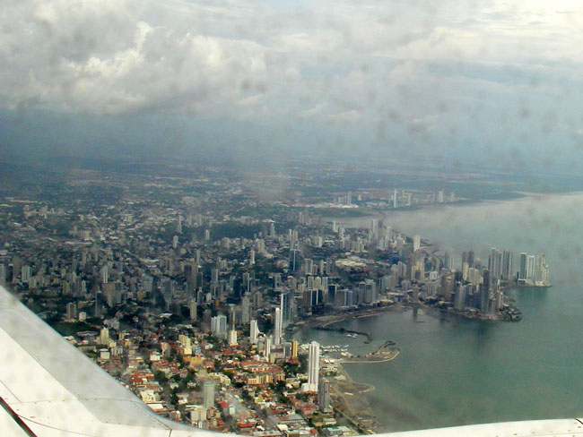
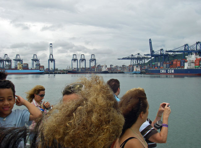
 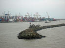 On
both the Pacific and Atlantic sides of the Canal, there are large ports with
a railway connecting the two. Ships that are either too large to
transit the Canal, or who don't have enough cargo to make a transit
worthwhile, are able to unload their cargo at either Colon or
Panama City
and have it transported by rail to the other side, saving a lot of money.
The railway was originally used to help construct the Canal. On
both the Pacific and Atlantic sides of the Canal, there are large ports with
a railway connecting the two. Ships that are either too large to
transit the Canal, or who don't have enough cargo to make a transit
worthwhile, are able to unload their cargo at either Colon or
Panama City
and have it transported by rail to the other side, saving a lot of money.
The railway was originally used to help construct the Canal.
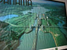 We first did a tour
on a small cruise boat that began in Gamboa (south of Gatún Lake) and
took us south through the Pedro Miguel and Miraflores Locks, and out to
Flamenco Island where commercial and pleasure vessels anchor. The first
part of the slide show is from that boat tour. The next day we
went by land to visit the Miraflores Locks where an observation deck
gave us an up-close view of the process. On site is also an
interesting museum. We first did a tour
on a small cruise boat that began in Gamboa (south of Gatún Lake) and
took us south through the Pedro Miguel and Miraflores Locks, and out to
Flamenco Island where commercial and pleasure vessels anchor. The first
part of the slide show is from that boat tour. The next day we
went by land to visit the Miraflores Locks where an observation deck
gave us an up-close view of the process. On site is also an
interesting museum.
The expansion project
began work in 2007 and will be completed in 2014, for a total cost of $5.2
billion. This includes enlarging Gaillard Cut. As mentioned
above, a 3rd traffic lane, also with 3 sets of locks, is being constructed
parallel to the existing 2 lanes. However, new features are being used
that make it even more efficient: Each lock has a series of 3 "pools",
or water reutilization basins, that
will either empty into the lock (raising the water level) or fill from the
lock as it is being emptied - this will allow for faster fill/empty times;
also, the water will be "recycled". Tug boats will be used instead of
the locomotive mules. The lock gates will slide (in/out of the
wall) as opposed to swinging open/close, which will require less effort and
be easier to maintain. View an animation of
how the
new locks will work.
| RUSSIAN
WARSHIP TO TRANSIT PANAMA CANAL
Dec. 4, 2008
update: This week the Russian navy has been
involved in joint maneuvers with the Venezuelan navy in
the Caribbean, Russia's first such deployment to the
Western Hemisphere since the Cold War era.
Yesterday, it was announced that a Russian warship will
sail through the Panama Canal tomorrow, the first time
since World War II. It will dock at a former U.S.
naval base. This transit is viewed mostly as
symbolic. |
|